


Driving out into Madoi county in May 2018. Much of this region has an average altitude of 4300m. Yang Yong, an independent Chinese geologist and environmentalist lead an expedition to explore new areas of desertification near the Yellow River headwaters. Temperatures were below freezing when we stayed in Madoi town the first night. The next day we headed out as the weather started thawing. The Tibetan Plateau is frequently described as the “third pole” by scientists because it holds the largest store of fresh-water after the Antarctic and Arctic. It is also the source of Asia’s major rivers, which support about 1.4 billion people downstream. The loss of its grasslands, alpine meadows, wetlands and permafrost will have serious implications for environmental security in China and South Asia.
FROM MADOI COUNTY, a settlement near the headwater of the Yellow River, our two-car convoy headed out to visit a desert Yang Yong first viewed through binoculars in 1997. At the time, the geologist had seen a small, wind-blown patch of sand surrounded by greenery. This time, Yang looked out past a stretch of sloping grassland to where a new desert extended beyond the horizon. That sandy expanse, Yang told me, was where we would spend the night.
Yang, now sixty, is one of China’s most prominent environmentalists. For nearly thirty years, he has studied environmental changes in the Tibetan plateau, in particular the region where the Yellow, Yangtze, and Mekong Rivers originate. Using satellite images, remote sensing, and data collected on expeditions, he and his crew are documenting the degradation of lands along the headwaters of China’s major rivers. In May 2018, I joined Yang on an expedition to capture the transformation of the Yellow River and its surrounding landscapes.
There are many forces causing desertification on the plateau, including natural physical processes, human mismanagement, and climate change. The land, which ranges from semiarid to arid, is unable to sustain high densities of human and wildlife populations, while the high altitude and dry climate can make it vulnerable to wind erosion. Rising temperatures accelerate the melting of permafrost, exposing once-frozen topsoil to winds and burrowing rodents. Some claim that overgrazing has contributed to the damage. The Tibetan plateau’s water cycle is also under severe stress, with shrinking glaciers, expanding lakes, and overflowing rivers in some parts.
Independent Chinese geologist and environmentalist, Yang Yong, looks pensive as he takes a cigarette break after a long drive. He has been making field studies of this 3 river source region (Sanjiangyuan National Nature Reserve) for close to three decades.
Driving past grazing yaks in the Sanjiangyuan National Nature Reserve in Qinghai. In the 1990s, China’s Yellow River began to dry up, and in 1997 it failed to reach the sea for several months. To address the problem, the government launched a scheme to protect the river’s source, a region about the size of Illinois called Sanjiangyuan (“Three River Source”) in northwest Qinghai province, which is also home to the sources of the Yangtze and Mekong rivers.
Rain clouds approach Madoi while the expedition group have lunch indoors on a mid-trip supply run for fuel and food supplies. With an elevation of around 4,300 m (14,000 ft), Madoi County has an alpine climate, with long, bitterly cold and severely dry winters, while summers are short and cool.
Driving past approaching rain clouds at an altitude above 4000m. The Qinghai Tibetan Plateau forms part of the 'water tower' of Asia, its large reserves of ice and permafrost help feed three of its most important rivers -- the Yellow, the Yangtze and the Mekong.
Circumnavigating the edge of a desert overlooking an icy Chachangqu River, a subsidiary of the Yellow River, and grasslands on the opposite bank. A 2015 Chinese Academy of Science (CAS) study states that over the last three decades an extra 2,745 square kilometres of land has been claimed by desertification in the headwaters of the Yellow River.
In search of a suitable camping site and after a series of incredibly deft manoeuvres by our expedition leader, Yang Yong, down steep slopes where no trail previously existed, we ground to a halt when the tires in soft desert sand failed to get any traction. We are on the border of an unnamed desert that has only recently formed in the past few years on the Qinghai Tibetan Plateau near the source of the Yellow River, a relatively uncommon occurrence at an altitude well above 4000m. The passengers are out, and so are some of our bags. Luckily we have others from the group in the second car to help. After digging, and scavenging for rocks in the desert we were finally able to reverse the car out of its predicament.
Geologist and activist, Yang Yong, leads his team along the edges of a desert in Madoi county. He says this is his first time returning to this particular site east of Madoi since 2009 where he saw dunes with his binoculars from the road. They tried to reach the desert off road at that time but their cars got stuck in the wetlands before they could reach the desert.
Independent Chinese geologist and activist, Yang Yong studies maps and satellite images on his phone. Among the counties in the source areas of the Yellow River, Madoi county is the closest to the headwaters and one of the most severely affected, with desertified land accounting for 35%, of the total land in the county.
Strong winds blow across a dune. A few tufts of grass in the foreground mark the edge of the grassland and where desert begins. There are many forces causing desertification on the plateau, including natural physical processes, human mismanagement, and climate change. The land, which ranges from semiarid to arid, is unable to sustain high densities of human and wildlife populations, while the high altitude and dry climate can make it vulnerable to wind erosion.
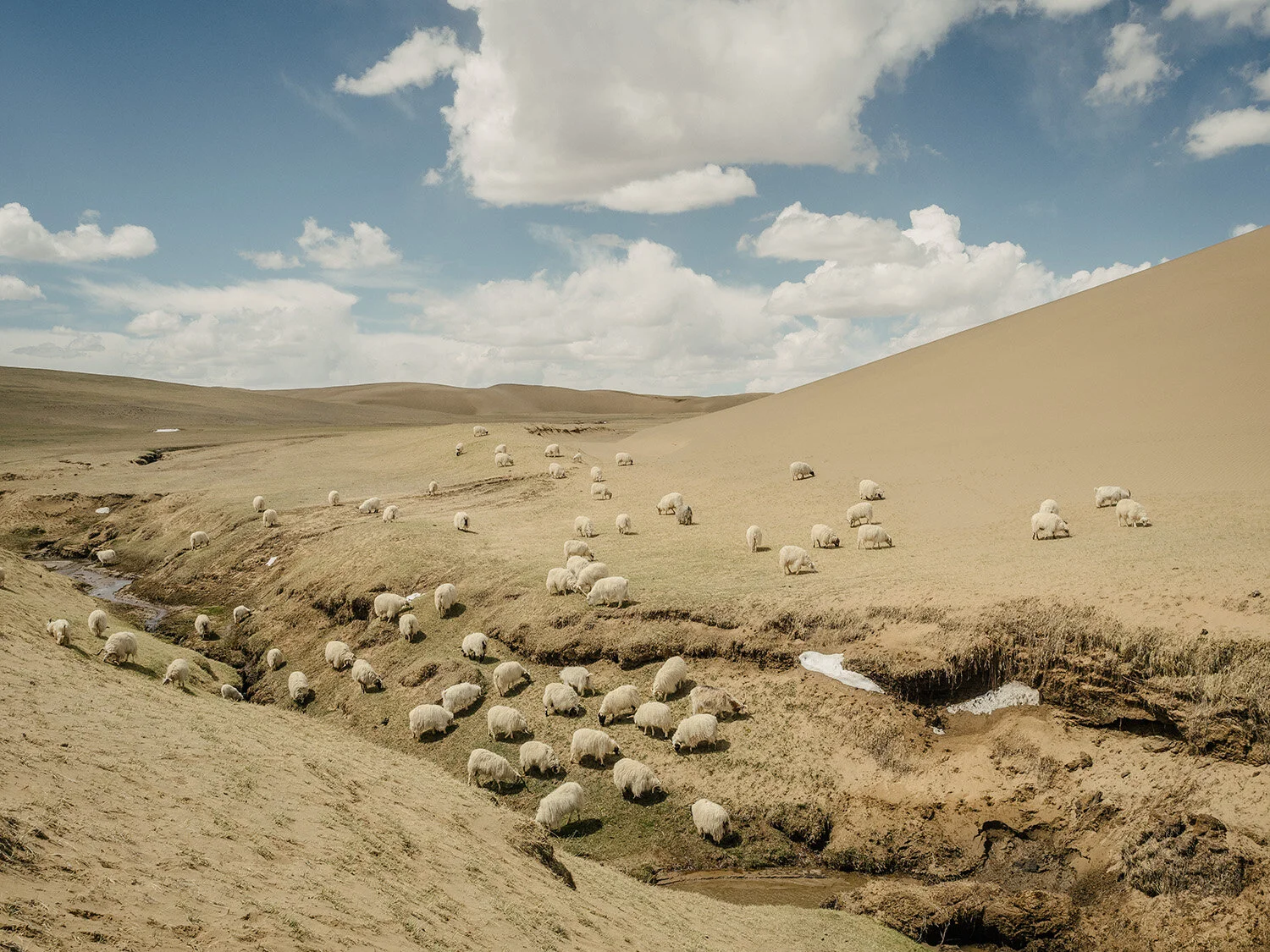
Sheep on the edge of a receding grassland. In a 2010 Shanghai Morning Post report by Ge Zhihao, the Qinghai-Tibet plateau today is a major source of water for Asia but may ultimately become a major source of sand in the future for the world.
Independent Chinese geologist and activist, Yang Yong, who has been studying the Sanjiangyuan National Nature Reserve (3 river source) observes the landscape from the top of a sand dune. He is on the edge of a desert that was once grassland.
Local Tibetans taking a break before continuing to the campsite to greet the rest of Yang Yong's expedition at the campsite. Among the counties in the source areas of the Yellow River, Madoi county, an area the size of Rwanda, is the closest to the headwaters and one of the most severely affected, with desertified land accounting for 35% of the total land in the county.
Approaching rain clouds in the desert while on route to a new location to set up camp. Animals graze in the distance. In Spring 2018, Chinese environmentalist, Yong Yang, sets out from his home in China’s western Sichuan Province with his brother, Hongbing, the expedition cook and co-driver, his friend affectionately called, Captain Lu, the drone operator, his apprentice, Xiao Wei, who assists and records much of Yang Yong's observations and his wife, Sisi, who handles the budget for the trip in two sport utility vehicles filled with camping and research equipment.
Dinner in the evenings is often cooked by Yang Yong and his brother Yang Hongbing, who is also one of the expedition drivers. Yang Yong is a prominent Chinese environmentalist, who has been studying the impact of climate change in the Sanjiangyuan National Nature Reserve and greater region for 30 years.
Yang Yong discusses with a Tibetan herdsman their location on a satellite map. "Although satellite imaging has documented the advance of these deserts above an altitude of 4000m, a rare occurrence generally," he claims, " there are rarely any expeditions or studies made on these newly formed deserts."
Local Tibetans greet Chinese environmentalist, Yang Yong, at the campsite next to Gangagenacuo Lake and Rigecuo Lake. The ground that they stand on show visible cracks, with sections of the frozen ground having melted and previously collapsed. This exposes the thin layer of fertile soil to strong winds and burrowing animals, like hares and pikas, further causing degradation and eventual desertification.
Tibetans walking across the grasslands between Gangagenacuo Lake and Rigecuo Lake. "The grassland here may look green and healthy, but the pockmarked cracks in the grass are the first signs of desertification starting," says Yang Yong, a Chinese environmentalist who has been studying the impact of climate change in this region for many years.
Yang Yong checks his location on his phone while driving to the next location he plans to explore. Throughout this expedition, he is exploring the 3 river sources area, also known as Sanjiangyuan National Nature Reserve in the northwest of Qinghai province. The region is home to the sources of the Yellow, Yangtze and Mekong rivers. The reserve was established in 2000 as a response to a national emergency when the Yellow River began to dry up and failed to reach the sea for several months in 1997.
Yang Yong, his wife, Sisi and his friend and drone operator they affectionately call Captian Lu, plan the next day's travels using a topographical map.
Glacier at Animaqen. Chinese environmentalist, Yang Yong, observes the Yellow River at its source isn’t fast flowing because of its heavy silt content and the gradient of the landscape being fairly flat. At the time of expedition in May 2018, Yang Yong observes many of the lakes and tributaries that usually connect to the Yellow River are no longer feeding into the river. He fears the Sanjiangyuan National Nature Reserve may one day no longer be the source of the Yellow River. Should this happens the glaciers of the Animaqen mountain range, some 300km drive further downriver, could potentially become the new headwaters of the Yellow River. Today the glaciers and snowmelt from Animaqen increase the river's volume by six times as it passes the mountain while its glaciers are rapidly retreating annually from warming temperatures.
The Tibetan Plateau spans an area five times the size of Spain and has an average elevation of 4,500 meters—a few meters higher than the peak of Switzerland’s Matterhorn. After the Antarctic and Arctic, the plateau has the third largest reserve of ice, a fact leading scientists to call it the “Third Pole,” and thus highlighting its relevance to the earth’s climate. As with the other two poles, temperatures in the Tibetan Plateau have been rising much faster than global averages, and many of its 46,000 glaciers are shrinking. The plateau rises deep into the earth’s atmosphere and therefore regulates the weather system throughout Asia. Often referred to as Asia’s “water tower,” the plateau’s lakes, glaciers, and wetlands support about 1.4 billion people downstream.
The Yellow River. Sanjiangyuan National Nature Reserve, Qinghai, China.
The Yellow River meanders through the edges of a recently formed desert at above 4000m on the Qinghai Tibetan Plateau. Globally deserts are rare at such high altitudes. The dunes in the distance mark the edges of an expanding desert on the east of Madoi county at the Sanjiangyuan (Three River Sources) National Nature Reserve. 35% of its total land is desertified, the most severely impacted county amongst others near the source of the Yellow River. The Tibetan Plateau is often known as “Asia’s Water Tower” and is the source of many of Asia’s major rivers but the headwaters of these rivers are today suffering from desertification and land degradation.
Wetlands I. Sanjiangyuan National Nature Reserve, Qinghai, China.
A wetland shows signs of desertification as morning fog lifts. According to a 2015 report by the Chinese Academy of Sciences, the Qinghai Plateau is warming two times faster than the global average and scientists predict temperatures will continue to rise a further 4.6 degrees Celsius by the end of the century. Consequentially, the water cycle is intensifying, as indicated by shrinking glaciers, expanding lakes and increased river flows. Meanwhile, desertification continues to spread as permafrost melts -- both are identified as major drivers of environmental degradation on the plateau. Wetlands rely on permafrost, its summer melt is a supply of water, while the year-round subsurface frozen layer prevents water from seeping beyond the soil and so benefits surface ecologies. In some places on the Qinghai-Tibetan Plateau, receding permafrost has accelerated the degradation of pasture and worsened desertification.
Grasslands. Sanjiangyuan National Nature Reserve, Qinghai, China.
The vulnerability of the plateau to aeolian desertification originates from its cold and dry climate, a result of its high altitude. This climate greatly reduces vegetation growth, and when vegetation is damaged or removed, recovery is slow or unlikely. Increases in temperature can hasten the melting of frozen soil, causing it to lose its structural support, which in turn exposes loose soil to strong winds that will cause further desertification— this can be seen in the crater-like structures on the hill in the right side of the frame. Climate change, especially rising temperatures, is an accelerant in this process.
Yaks Grazing in Desert. Sanjiangyuan National Nature Reserve, Qinghai, China.
Yaks grazing by a lake surrounded by dunes at the Sanjiangyuan (Three River Sources) National Nature Reserve at an altitude of 4300m. Experts disagree about whether grazing herds are exacerbating the desertification of grasslands — some believe that human activity, such as gold mining in the outer regions of the reserve, bears more responsibility. Desertification at such a high altitude is rare globally but it has become increasingly common in recent years. This region, Madoi county, has desert accounting for 35% of its total area.
Sand Dune and Grasslands. Sanjiangyuan National Nature Reserve, Qinghai, China.
A dune marks the edge of a relatively new desert expanding into grassland. According to a 2015 report by the Chinese Academy of Sciences, the Qinghai Plateau is warming two times faster than the global average and scientists predict temperatures will continue to rise a further 4.6 degrees Celsius by the end of the century.
New Highway and Lakes. Madoi, Qinghai, China.
A new highway recently constructed leading up to Madoi County at an altitude of 4300m. The region has an alpine climate, with long, bitterly cold and very dry winters, and brief, cool summers. It is not uncommon to drive on sections of buckled roads, a result of the freezing and thawing of the permafrost layers under the tarmac.
Anemaqen Glacier. Maqin, Qinghai, China.
Chinese environmentalist, Yang Yong, observes the Yellow River at its source isn’t fast flowing because of its heavy silt content and the gradient of the landscape being fairly flat. At the time of expedition in May 2018, he observes many of the lakes and tributaries that usually connect to the Yellow River are no longer feeding into the river. He fears the Sanjiangyuan National Nature Reserve may one day no longer be the source of the Yellow River and if this should happen, the glaciers of the Animaqen mountain range, some 300km drive further downriver, would potentially become the new headwaters of the Yellow River. Today the glaciers and snowmelt from Animaqen, claims Yang Yong, increases the river's volume by six times as it passes the mountain while its glaciers are rapidly retreating annually from warming temperatures.
Maqen, Qinghai, China.
The Tibetan plateau covers all of the Tibet Autonomous Region, much of Qinghai province, and parts of Sichuan province, stretching for 965,000 square miles, an area larger than Alaska, Texas, and Nevada combined. The resettlement of a once nomadic people has compressed the space humans and animals occupy on the plateau. Studies have shown that the plateau and its delicate ecology are better equipped to withstand human populations that are spread out rather than concentrated into high density conurbation areas like towns and cities. Research data indicate the total population in 2010 at the Sanjiangyuan (Three River Sources) National Nature Reserve increased by 26.7% since 2000.
Grasslands. Sanjiangyuan National Nature Reserve, Qinghai, China.
Permafrost are perennially frozen layers of soil underpinning two-thirds of the plateau and provide essential carbon and water storage. Rising temperatures cause increased permafrost-melt resulting in sections of grassland collapsing when the supporting structure of the frozen ground is lost. Although this is part of a natural process that feeds water into the delicate surface ecology during the summer, the cycle has continued to intensify. Yang Yong, a geologist who has been studying this region for the past 30 years points out these pockmarked surfaces of the grassland to be a sign of desertification at the early stages. These partially collapsed sections expose soft soil to the wind and burrowing mammals like pika whose predators have been over-hunted — a process that continues to worsen over time.
Wetlands II. Sanjiangyuan National Nature Reserve, Qinghai, China.
According to a 2015 report by the Chinese Academy of Sciences, the Qinghai Plateau is warming two times faster than the global average and scientists predict temperatures will continue to rise a further 4.6 degrees Celsius by the end of the century. Together with melting permafrost, worsening desertification is identified as the major driver of environmental degradation on the plateau. Wetlands rely on permafrost – summer melt supplies wetlands with water, while the year-round subsurface frozen layer prevents water from seeping deeper into the soil and so benefits surface ecologies. In some places on the Qinghai-Tibetan Plateau, receding permafrost has accelerated degradation of pasture and worsened desertification.
Lijiaxia (Gorge) Dam I. Qinghai, China.
China's powerful rivers and simultaneously stretched water resources, especially in the north, have produced great agricultural bounty but historically have also caused devastating floods. Ever since irrigation was fully developed in ancient China, river management - shui zheng - has been an important function of governance, playing a significant role in the lives of ordinary people. A fundamental difference in river management in pre-communist China and thereafter is the construction of large hydroelectric dams. In 1949 the country had less than 40 small hydroelectric dams and only a handful of large-scale reservoirs. By 1985, the state-organized drives for electricity, irrigation, and flood control succeeded in building 70,000 dams and 80,000 reservoirs, and of these nearly 300 were big hydroelectric dams and 340 were large-scale reservoirs. Today, these hydro-projects have resulted in the relocation of 23 million people.
Lijiaxia (Gorge) Dam II. Qinghai, China.
The Lijiaxia Dam, measuring at 155 metres high has a capacity of 1.65 billion cubic metres, is a significant concrete arch dam on the upper reaches of the Yellow River. The Lijiaxia dam, built in the 90s, is one of eight cascade dams on the Longliu Section built between 1977 and 2006. After the construction of these hydropower projects, the peak streamflow shifted from summer to autumn months. Furthermore, the speed of its monthly streamflow between the inlet and outlet at the Longliu Section dropped severely. These drastic changes to the natural flow of the river can have significant outcomes on water availability downstream. The operation of dams for multiple uses including water diversion for irrigation has resulted in the lower reaches of the Yellow River drying up since the 70s, with stretches of the river drying up to 30 times and the longest duration lasting 230 days in 1997. Since 2000 well-timed releases of reservoir water have stopped the river from drying up.
China continues to build new dams and aims to generate 120,000 megawatts of renewable energy, mostly from hydroelectric power by 2020. The state declares such dams are safe and enhance human life by avoiding pollution, addressing the future of climate change while controlling floods and droughts. There are, however, experts and studies that challenge this perspective.
Road to Lijiaxia (Gorge) Reservoir. Qinghai, China.
A road cuts through a parched landscape towards the verdant gorges of the Lijiaxia reservoir. This yellowish scene is typical to the drylands of the Loess Plateau, an area about the size of France, its soils are particularly prone to erosion by wind and water. In 2017, for the first time, China hosted a major global event on desertification and land degradation, the Cop-13, United Nations Convention to Combat Desertification. 113 countries had agreed to specify concrete targets with clear indicators, to rehabilitate more land and reverse degradation, which currently affects over a third of the world’s land resources.
Terraced fields. Yongjing, Gansu, China.
China produces food for a fifth of the world´s population with only 7% of the world’s arable land, of which 65% of its agriculture is situated in the dryland region of northern and north-western China. The Loess Plateau is part of this region, an area the size of France, its soil is very fertile and easy to farm, a characteristic that helped make it the cradle of Chinese civilization. It is however also prone to wind and water erosion. Centuries of mismanagement has resulted in degraded lands and in huge sediment loads in the Yellow River. It’s estimated more than two-thirds of the Loess Plateau Region is affected by soil erosion. Up to three billion tonnes per year of sediment load was observed in the Yellow River in the late 1950s but that has since declined significantly due to practices such as landscape engineering, terracing and the construction of check dams and reservoirs in the 1970s to 1990s. Agriculture is by far the largest water consumer in the Yellow River Basin, accounting for 80% of its total withdrawal.
Yellow River. Guide, Qinghai, China.
The populous agricultural town of Guide set against arid loess landscapes, its lush vegetation is fed by multiple reservoirs situated upriver. At 2200m it enjoys relatively mild weather, and its emerald green waters belie the fact that it is one of the most silted rivers in the world. This becomes apparent as it turns a characteristic yellow further downriver past the Ordos Loop in Inner Mongolia. As the river meanders through to its Delta it carries on average 1.6 billion tons of silt annually at the point where it descends from the Loess Plateau and if it is running to the sea with sufficient volume, 1.4 billion tons are carried to the sea annually.
Tree Planting. Guide, Qinghai, China.
Young trees grow on the hillside. The dirt tracks are routes made by workers driving tractors to tree planting sites. The efforts of slowing the advance of deserts are made by a government tree-planting program, the Green Great Wall. It is estimated by 2050, the artificial forest will stretch 400 million hectares, covering beyond 42 per cent of China’s landmass. However, continued doubts remain about the impact of this green campaign. Some critics say the type of forests planted, and their location, limit their effectiveness, arguing the Great Green Wall has contributed to a significant decline in China's forest quality, and in some places, accelerated ecological degeneration by putting pressure on precious water resources in arid and semi-arid regions.
New Highway and Grasslands. Qinghai, China.
In 2000, the Chinese government recognised that an environmental crisis was underway and created the Sanjiangyuan National Nature Reserve, stretching for more than 140 square miles over China’s Tibetan plateau. In recent decades, as China’s cities and economy have grown rapidly, the plateau has been increasingly explored for resource extraction and economic development. The infrastructure necessary to move supplies and resources has further altered the landscape as road construction projects cut through the plateau.
Highways to Industrial District. Lanzhou, Gansu, China.
New highways in the industrial district of Lanzhou. Since 1949 the city once a former Silk Road trading post, has morphed from the capital of a poverty-stricken province into the heart of a major industrial area. It is the centre of China's petrochemical industry and is a key regional transport hub between the country's east and west. In recent years the city continues to place an increasing burden on the river. Heavy-industry and the pressures of urbanisation have taken a toll — growing cities require more power meaning the burning of more coal, and city dwellers use five times more water than their rural cousins.
Road Construction and Car Plant. Lanzhou, Gansu, China.
Sections of mountains are being carved up behind a car factory to make way for a new road. Since 1949, Lanzhou, once a former Silk Road trading post, has morphed from the capital of a poverty-stricken province into the heart of a major industrial area. It is the centre of China's petrochemical industry and is a key regional transport hub between the country's east and west. In recent years the city continues to place an increasing burden on the river. Heavy-industry and the pressures of urbanisation have taken a toll — growing cities require more power meaning the burning of more coal, and city dwellers use five times more water than their rural cousins.