


We journeyed to that treacherous point where the Pacific and Atlantic oceans meet. We were looking for something no one had ever seen and were prepared to climb up or rappel down a knobby face above the deadliest seas on Earth to find it. We've flown across oceans; chugged 32 hours by ferry; motored 10 hours more on a wooden charter boat captained by a sailor who confessed mid-journey that he'd never navigated this deadly stretch of sea. Only then did we reach our destination—Isla Hornos, Cape Horn island, the last spit of ground in Tiera del Fuego. There we've hiked and camped through gales that knocked us down, slipped on penguin guano, and vanished to our necks in prickly shrubs.
To be unimpressed at first glance is entirely reasonable. It's just a tangle of gnarled limbs and silver bark hidden by reedy grass. Seven trees sprout on a hillside near the southern tip of South America, above the treacherous swirl of spray where the Pacific Ocean meets the Atlantic. A few of them are dead. None reaches higher than my thigh. The living bend and curl their way a dozen feet across the ground, like soldiers clawing through battlefield mud. Furious winds have driven their trunks completely horizontal. It's hard to square these scraggly specimens with the exceptional lengths we've gone to find them.
We've come all this way to map a border no scientist has mapped before. We've come to find Earth's southernmost tree.
Abridged Text by Craig Welch, from the original National Geographic article. Read the full article on The Southernmost Tree link on the left menu bar in light grey.
Isla Hornos viewed from the south side at its horseshoe-shaped bay. The island at 10 square miles is shaped like a beetle. The western arm of the horseshoe rises to the top of the Cape headwall. All of the research activities over the ten days on Isla Hornos occurred in the south side of the island as seen in this panoramic photo.
1. The anchor site and first point of arrival by boat on the Oveja Negra.
2. Lighthouse. Only Chilean Navy Officer Andrés Morales and his family live on this island throughout the year.
3. Albatross sculpture by José Balcells Eyquem in 1992.
4. The approximate route the trek took from the lighthouse to basecamp.
5. Basecamp and the approximate location a Texas researcher scours thin nearby streams for insects.
6. Pebble beach area where penguins enter the sea. Also, the more accessible route to reach further south of the island.
7. An anchor site for the Oveja Negra to bring supplies to the expedition near basecamp. Stormy weather meant visits would sometimes be cut short and the boat would take shelter at anchor site 1.
8. Site where ornithologist assistant, Omar Barroso Putare, catches birds in his mist net and tags them.
9. Location of spearpoint and archaeological site discovered by the archaeologic team, Miguel Troncoso and Flavia Morello.
10. Epiphyte and tree canopy researcher, Ivan Diaz, measures Megallanic Southern Beech trees and collects Epiphytes samples.
11. Site of the southernmost tree and search area. A Megallanic Southern Beech tree discovered by scientists Brian Buma and Andres Holz.
12. The area searched and the route taken by the Oveja Negra as it sailed as near as it was possible to exposed rocks. Aboard the boat, scientists Brian Buma, Andreas Holz and Paolo Rozzi viewed the cliff edges with binoculars.
13. Location of where scientists extracted pollen cores. It is possible to analyze for vegetation composition over millennia.
14. Primary location for the floristic survey.
Captain on the bridge of the local ferry linking Punta Arenas to Puerto Williams. The boat travels through the Straits of Magellan to the outer coast before re-entering the small waterway channels of the Chilean fjords to make its way south through the historic Beagle Channel. The inlet named after the HMS Beagle once brought the young naturalist Charles Darwin through its waters where he saw his first glaciers on 29 January 1833. The journey today takes some 32 plus hours and passes some of the most dramatic and beautiful glacial landscapes in the Tierra Del Fuego region before arriving at its final destination in Puerto Williams, the southernmost city in the world.
View from the bridge of the local ferry linking Punta Arenas to Puerto Williams, the southernmost city in the world.
Journey through the Straits of Magellan to the outer coast before re-entering the small waterway channels of the Chilean fjords to make its way south through the historic Beagle Channel.
It was on the ferry from Punta Arenas to Puerto Williams, a windy, 32-hour journey through many of the same waters a young Charles Darwin described in “The Voyage of the Beagle,” when expedition leader Brian Buma, finally had a few moments to himself. Noting his thoughts to paper with detailed hand-drawn maps and plants species in a little yellow hard-bound notebook, he visualises our coming days on a still relatively unexplored little island to this day: Isla Hornos, Cape Horn island.
The northwest arm of the Beagle Channel runs through the appropriately named Glacier Alley or Avenue of the Glaciers where glaciers flow from the Alberto de Agostini National Park into the Beagle Channel.
Scientist and co-leader of the scientific expedition, Ricardo Rozzi, studies a map of the route to Puerto Williams on the bridge of the local ferry.
The dagger peaks of the Dientes de Navarino mountains draw tourists to Puerto Williams, on the Beagle Channel.
Many tourists take the ferry from Punta Arenas, chugging past icy fjords through the moonlit waters of the Strait of Magellan in the hope of doing a trek to view the dagger peaks of the Dientes de Navarino mountains.
A view of Puerto Williams and the Beagle Channel during a moonlit night. The small city is the main settlement, port and naval base on Navarino Island in Chile. Puerto Williams claims the title of the world's southernmost city.
Ezio—former chef, former part-time researcher, now owner, builder, and captain of the remarkable 65-foot wooden boat Oveja Negra — steers the boat along the Beagle Channel while scientist and co-expedition leader, Ricardo Rozzi, is on the phone.
Brian Buma, scientist and expedition leader, discussing trip plans with Chilean conservationist, Ricardo Rozzi. The latter has done extensive studies in this region and plays an important role in providing logistical support for the upcoming fieldwork research on the expedition on Isla Hornos.
A horse crossing the street, one of many typical street scenes in Puerto Williams. The small city is the main settlement, port and naval base on Navarino Island in Chile.
Crew loading a dinghy onto a truck for delivery to the Isla Hornos expedition boat, the Oveja Negra, a name that means black sheep in Spanish.
Eizo, the co-captain and owner of the Oveja Negra, directs the loading of a dinghy onto this remarkable 65-foot boat handbuilt lovingly by him. The Oveja Negra will take this scientific expedition to Isla Hornos in the hope of finding the southernmost tree in the world.
View of Puerto Williams and the Beagle Channel. The small city is the main settlement, port and naval base on Navarino Island in Chile.
Having loaded the Oveja Negra, scientist and expedition leader, Brian Buma, waits pensively for the rest of the team to arrive. The journey to Isla Hornos will take approximately 12 hours. The expedition represents a unique journey to a place rarely seen, whose purpose according him is “to tackle a question that no one has answered, one that encapsulates both the limits of current life and the potential for future change: Where is the planet's southernmost tree, what does it look like? What can it tell us about our past, and about where we're heading? Unlike the northern hemisphere, almost all Sub-Antarctic landscapes are made up of remote, ecologically isolated islands. Scientists know little about how these isolated ecosystems will respond as species move poleward with climate change. The southern tip of South America is one of the most remote, "end of the road" locations where a series of unique species have weathered past climatic shifts - though they are now faced with a much larger, directional change. How will they fare? Will forests expand south into new landscapes? How can conservation practices cope, and adapt, and best share knowledge between hemispheres? We don't know the full answer to any of these questions currently; through our project, we will take readers to this current limit of forest-life and generate baseline data for decades of future research.”
Professor of Geography and forest ecologist, Andres Holz, in a discussion with scientist and expedition leader, Brian Buma, about their plans for the upcoming trip to Isla Hornos.
Scientist and expedition leader, Brian Buma, looks at his notebook with preliminary plans and sketches for the upcoming trip on Isla Hornos.
The landscape along the Beagle Channel as the Oveja Negra, meaning black sheep in Spanish, heads in a westerly direction before turning southward on Murray Channel towards Isla Hornos.
A rainbow over the landscape along the Beagle Channel.
Co-Captain, Pablo, navigates the 65-foot (20m) wooden boat, the Oveja Negra, on the Beagle Channel as it heads towards its final destination: Isla Hornos.
Professor of Geography and forest ecologist, Andres Holz, and scientist and expedition leader, Brian Buma, take in the view as the Oveja Negra chugs its way to Isla Hornos in the late evening.
The landscape along the Beagle Channel as the Oveja Negra heads in a westerly direction before turning southward on Murray Channel towards Isla Hornos.
Scientist and expedition leader, Brian Buma, having a quiet moment on route to Isla Hornos. He specialises in high latitude temperate rainforests, a specialism that is also appropriate to the extreme southern latitudes of Isla Hornos.
Collecting freshwater supplies for the Oveja Negra from a gushing stream entering the sea.
Dinner on the first night of the expedition to Isla Hornos on the Oveja Negra, a 65-foot (20m) wooden boat handbuilt by the captain and owner, Eizo. Member scientists of the expedition, Andres Holz, Brian Buma and Ivan Diaz (nearest to the doorway) can be seen in the foreground.
A discussion with scientist and expedition leader, Brian Buma, Chilean conservationist, Ricardo Rozzi, and the rest of the team about the disembarkation plans for Isla Hornos the following day. In the past, the island has been little explored, and there is little information about the terrain at its southern tip.
The drawings of Isla Hornos in Brian Buma's notebook. He specialises in high latitude temperate rainforests, a specialism that is appropriate also to these extreme southern latitudes of Isla Hornos.
Co-Captain, Pablo, navigates the 65-foot (20m) wooden boat, the Oveja Negra, on the Beagle Channel as it head towards its final destination: Isla Hornos.
Members of the scientific expedition disembark onto Isla Hornos and help unload the dinghy. The rocks are incredibly slippery, and the captain has to time the landing with the ebb of the waves so passengers can disembark safely.
Scientist and expedition leader, Brian Buma, takes a peek into the church to greet other team members of the group that had arrived a few days earlier. After a few days of camping, the group chose to stay at the church because of extreme weather conditions.
Chilean Navy Officer Andrés Morales and his family — they are the only living souls on this island barring the occasional passing cruise ship throughout the year. Or on this occasion, adventuring scientists about to explore the island away from the shelter of this small outpost. In the coming days, Morales would keep us abreast of weather conditions by radio on an island notorious for its gales, and unpredictable weather. Chilean Navy Officer: Andrés Morales; spouse: Catalina Henriquez; Kids: Martín, Amanda (2 years), and Isidora.
Expedition members trek in search of basecamp in a south-westerly direction from the lighthouse. In the foreground are Nothofagus Betuloides, Megallanic Southern Beech trees, strong winds have forced its gnarled branches to grow along the ground to protect itself from the extreme weather of Isla Hornos. The journey, with some members carrying heavy supplies up to 30 kilos on their backs, soon gave way to quicksand-like bogs and chest-deep snarls of thorny brush. It took three hours to hike little more than a mile. Without the strong winds, the temperature was 6 degrees Celcius. But since the billowing gusts never abated, it felt like it was freezing from the start.
Expedition leader and scientist, Brian Buma, treks to the campsite where other members of the team had previously pitched their tents in the distance. He continues the journey, and rarely in the straightest most direct line because the ground constantly gives way to sinkholes and chest-deep snarls of thorny brush.
Penguins are hidden away in the vegetation, a view of the landscape on Isla Hornos seen not far from the campsite.
Heading out into the field to begin the search for the southernmost tree. Having ruled out the possibility of trees growing on the cliff face of Cape Horn, Brian Buma and the team head south towards the Horn to explore areas further south. Fear of approaching bad weather has made this a priority for today. The landscape on Isla Hornos look like pastel meadows you could have a pleasant stroll in, except the Nothofagus Betuloides trees, are sometimes hidden in creeks, making the ground before you appear largely flat until you disappear underneath it -- as was the case when the expedition first arrived. But today, having established pathways, the team use the trees to help them cross the creek.
A Nothofagus Betuloides (Megallanic Southern Beech) forest growing in a sub-Antarctic moorland and a dwarf forest on Isla Hornos.
A measuring tape hangs on a branch of a Nothofagus Betuloides, also known generally as Megallanic Beech. In the distance, the Oveja Negra is anchored near the shores of Isla Hornos.
Captain and owner of the Oveja Negra, Eizo, steers his boat towards the southernmost part of the island. The aim on this day is to search for any trees growing on the southern cliff face of Isla Hornos, Cape Horn.
On a clear and calm morning, Brian Buma and Andreas Holz scan for trees growing along the steep face of Cape Horn.
Making dinner whilst huddled amongst the vegetation to shield bodies and stove away from freezing winds.
An approaching rain front coming from the south towards the campsite. The peak in the distance is Cape Horn, and it marks the northern boundary of the Drake Passage where the Atlantic and Pacific Oceans meet. With over 800 shipwrecks and 10,000 lost lives between 1870 and 1914 before the completion of the Panama Canal, the Drake Passage between Cape Horn and Antarctica became infamously known as the most treacherous ocean waters on the planet.
The team at the site where the world’s southernmost tree is found. They will collect data measurements and place temperature sensors in the area. This will be a plot they will return at a future date to collect further data.
The terrain is so difficult to move around in that Brian Buma throws his measuring tape to the point where he wants it to be. The team are at the site where the southernmost and the penultimate southernmost tree is located. They will collect data measurements and place temperature sensors in the area.
Brian Buma measures the height of the southernmost tree, while Andreas Holz attempts to take a coring sample. The tree measured 55cm tall and 4.9cm in diameter at the base and for reference, the more photogenic, partially dead one 2m to the north, was 85cm tall and 8.6cm in diameter at the base. This will be a plot they will return at a future date to collect further data. The expedition represents a unique journey to a place rarely seen, whose purpose according to scientist and expedition leader, Brian Buma and his team is “to tackle a question that no one has answered, one that encapsulates both the limits of current life and the potential for future change: Where is the planet's southernmost tree, what does it look like? What can it tell us about our past, and about where we're heading? Unlike the northern hemisphere, almost all Sub-Antarctic landscapes are made up of remote, ecologically isolated islands. Scientists know little about how these isolated ecosystems will respond as species move poleward with climate change. The southern tip of South America is one of the most remote, "end of the road" locations where a series of unique species have weathered past climatic shifts - though they are now faced with a much larger, directional change. How will they fare? Will forests expand south into new landscapes? How can conservation practices cope, and adapt, and best share knowledge between hemispheres? We don't know the full answer to any of these questions currently; through our project, we will take readers to this current limit of forest-life and generate baseline data for decades of future research and collaboration between the different scientific disciplines.”
Epiphyte and tree canopy researcher, Ivan Diaz, ascending a Nothofagus Betuloides tree (Megallanic Southern Beech), the same species of tree as the southernmost tree just found. He collects samples of Epiphytes at different heights from the trunk and measures the tree height. In this area, on the slopes of a hill, the trees are significantly taller, most likely due to the less exposed conditions, than the southernmost tree which is less than a 1 metre in height. The tallest tree measured by Ivan was 10 metres.
A Nothofagus Betuloides (Megallanic Beech) forest on Isla Hornos. Ornithologist assistant, Omar Barroso Putare, has set up mist nets on the edges of this forest to catch and tag birds.
Ornithologist assistant, Omar Barroso Putare, measuring a bird. He caught the bird in a mist net, a fine net that is barely discernible to the eye. The net is designed to catch birds for tagging and to collect measurable data such as size, sex, and whether or not they had been sitting on eggs (by examining the chest feathers). With more years of data, it is possible to look at those variables to assess changes. Still, since this project is relatively new, he is mostly trying to determine how many bird species there are and some basic morphometrics (size, shape, etc.)
Brian Buma places temperature sensors on the Nothofagus Betuloides (Megallanic beech) tree canopy. He says, "The purpose of getting canopy, ground and root temperatures is to determine if local temperatures are limiting tree growth upward, away from the ground. If so, then there's good reason to believe that they will grow bigger and taller with climate change. If not, then perhaps it's something else, such as wind, limiting height."
Temperature sensors on the ground and root levels of a Nothofagus Betuloides (Megallanic beech) tree.
Notebook showing measurements of tree height and other data recorded. The team collect data measurements, coring samples and place temperature sensors in the area.
Field support and climbing guide, John Harley, takes a break to check the view after having helped with measuring the height of various trees. They are collecting data from another plot further north from the southernmost tree. This area is less exposed to the weather elements. As a result, the Nothofagus Betuloides (Megallanic beech) trees seem to thrive better by growing bigger and taller -- on average approximately 4 metres high.
Archeologist, Flavia Morello, Epiphyte and Tree Canopy Researcher, Ivan Diaz, Scientist and Expedition Leader, Brian Buma and Forest Ecologist, Andres Holz. - look at their first core from the ground. Scientist and leader of the expedition, Brian Buma, says, "The purpose of coring the ground was to see what vegetation on the island looked like in the past. The places where we took the cores were little depressions that would collect things washing off the hill above, and in principle the lower you go, the further back in time you look because new stuff washes in on the old stuff. So, we want to see if we can pinpoint the arrival of trees on the island by looking for either macrofossils like leaves or for pollen. Ideally we'll find a level where there is no tree pollen - below that is the time prior to trees. We can then date any carbon material that we can find (assuming we can) and get an approximate timeline for when trees arrived. It is of course also possible that trees were there when that moor started forming (or it's been washed out) and so it isn't old enough - just don't know yet. We found three good spots, deep (and so presumably the bottom is old). We took cores down to 2.43m in one location. Each core is about 5 cm across."
Tree Canopy Researcher, Ivan Diaz, Scientist and Expedition Leader, Brian Buma and Forest Ecologist, Andres Holz attempt to drive the Russian Coring tool into the ground. They are assisting the archaeological team with collecting samples for analysis back at the laboratory.
Penguins on their way back from the sea are startled by our presence on this rocky beach on Isla Hornos when we walk back to camp. This route is part of our daily trek to some of the southernmost plots for the team's fieldwork every day.
Forest ecologist, Andres Holz, takes a break while walking back to the campsite after a days work.
Nothofagus Betuloides trees (Megallanic beech) with its bare branches in a sub-Antarctic moorland and dwarf forest. These sub-Antarctic plants can thrive in windy and exposed areas but are a challenging environment for the trees. The plants hug the ground, and sometimes the trees too, for wind protection and to stay warm.
Scientist and expedition leader, Brian Buma, and Forest ecologist, Andres Holz, hiking to the lighthouse on the last day. They plan to do some soil coring in this part of the island and will board the Oveja Negra to join the rest of the team after their work is done before heading back to Puerto Williams.
Calm waters in the Pacific Ocean viewed from Isla Hornos. With over 800 shipwrecks and 10,000 lost lives between 1870 and 1914 before the completion of the Panama Canal, the Drake Passage between Cape Horn and Antarctica became infamously known as the most treacherous ocean waters on the planet.
This region is notorious for monster storms with winds gusting routinely over 100 mph, fueled by the merger of warm and cold ocean currents of the South Pacific and Atlantic Oceans, and the temperature gradient from the Antarctic ice sheet to the south.
The stairs from the lighthouse at Isla Hornos to the beach where the Oveja Negra awaits.
A memorial commemorating Vice-Admiral Robert FitzRoy FRS (5 July 1805 – 30 April 1865), who was an English officer of the Royal Navy and a scientist. He achieved his fame as the captain of HMS Beagle during Charles Darwin's famous voyage, FitzRoy's second expedition to Tierra del Fuego and the Southern Cone.
Oveja Negra anchored off the coast of Isla Hornos. Nothofagus Betuloides trees (Megallanic beech) with its bare branches in a sub-Antarctic moorland. These sub-Antarctic plants can thrive in windy and exposed areas but are very challenging for trees. The plants hug the ground (and sometimes the trees too) for wind protection and warmer temperatures.
A view of Cape Horn. With over 800 shipwrecks and 10,000 lost lives between 1870 and 1914 before the completion of the Panama Canal, the Drake Passage between Cape Horn and Antarctica became infamously known as the most treacherous ocean waters on the planet.
A view towards the lighthouse on Isla Hornos. In the foreground are pale green cushion plants in a sub-Antarctic moorland.
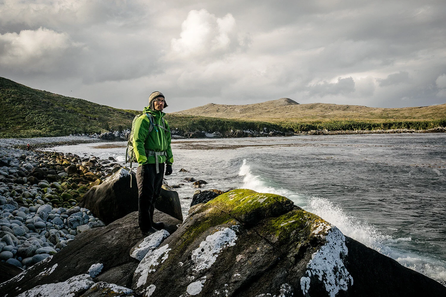
Scientist and expedition leader, Brian Buma, soaks up the view on the last day before hiking to the lighthouse. He and some members of the team plan to do some soil coring in this part of the island and will board the Oveja Negra to join the rest of the team after their work is done to head back to Puerto Williams.